Which participants determine the speed of withdrawal at online roulette demo? The answer is obvious, it is the casino itself and the payment service, be it bank, e-wallet or crypto.
Recourse to technology saves lives as flood cause chaos in Bihar
Every year the unpredictable nature of Koshi river affects the human lives, livelihood and livestock in Bihar. Almost 76% population of North Bihar lives under the recurring threat of devastating floods.
The heavy rainfall in the catchment area of Nepal cause spate in the rivers originating from the Himalayan region. The rivers especially Koshi crossing Bihar breaks their embankments and causes a flood. In 1954-1955, embankments were constructed in either side of the river to control the water which slowed down the speed but gradually the siltation started. The people of Bihar have experienced a massive flood in 2008 which affected 412 Panchayats, 993 villages and taken 493 lives with 3,500 missing.
Though the embankments were made the erratic weather patterns and increased number of intense rainfall events could not stop floods which have become unpredictable and intractable.
This year, the situation changed, when the flood occurred, no human life was lost because people received an early warning about the rising levels that provided enough time to prepare and evacuate before the floodwaters hit.
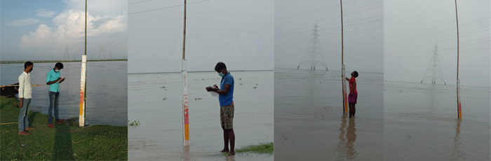
The Members of the Disaster risk reduction committee established the community based early warning System in Bega of Borha Panchyat district Supaul Bihar. After the discussion, the DRR committee installed measuring Pillar at Benga to monitor the water level at Koshi river. For Indication, community members Installed a tall bamboo of 30 ft’ and used white, yellow and red flags to signal the community about the water level.
It is a part of the contingency plan developed by the community with the support of Caritas India and activated in June 2020 which will continue till the flood season.
Community created a WhatsApp group “Koshi Ganga Aapda jokim suchna” to issue alerts to the Panchyat raj members, DRR committee, Taskforce members PRS Kisan Salahkar and Panchyat secretary as Government official and project staff on the status of water level.
Through this group, discharge reading from Chatar (Nepal) hydrological station is shared by the members on a regular interval (6:00 AM, 10:00 AM, 2:00 PM & 6:00 PM from Nepal Hydrological department website http://hydrology.gov.np/). Based on the information, task force members at the village level used to take water level reading and maintain the data in a register and share the same in the WhatsApp group. A team of Taskforce analyzes both data and used an appropriate flag to share the warning messages through a megaphone.
Community participation and proactiveness has helped in preparedness towards floods. The recent flood has proved that timely and proper early warning helps in timely evacuation saves human lives and livestock.
Our Sponsors


Social Links


Copyright Caritas India 2013 ! Developed by Neural Info Solutions Pvt. Ltd.